Proyecto
Comunidad
Noticias
Mi aplicación
Mis mapas
A general plan of the woods, park and gardens of Stowe the seat of the right honourable the Lord Viscount Cobham
1739
1:5k
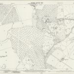
Buckinghamshire XIII.NW - OS Six-Inch Map
1950
Ordnance Survey
1:11k
Buckinghamshire XIII.NW - OS Six-Inch Map
1920
Ordnance Survey
1:11k
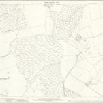
Buckinghamshire XIII.NW - OS Six-Inch Map
1899
Ordnance Survey
1:11k
Buckinghamshire VIII.SW - OS Six-Inch Map
1950
Ordnance Survey
1:11k
Buckinghamshire VIII.SW - OS Six-Inch Map
1899
Ordnance Survey
1:11k
Northamptonshire LX.SW - OS Six-Inch Map
1882
Ordnance Survey
1:11k
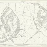
Buckinghamshire VIII.14 (includes: Akeley; Lillingstone Dayrell; Stowe) - 25 Inch Map
1899
Ordnance Survey
1:3k
Buckinghamshire VIII.14 (includes: Akeley; Lillingstone Dayrell; Stowe) - 25 Inch Map
1880
Ordnance Survey
1:3k
Buckinghamshire XIII.2 (includes: Akeley; Stowe) - 25 Inch Map
1938
Ordnance Survey
1:3k
التاريخ
Mapas antiguos de Stowe (condado de Lamoille)
Descubra el pasado de Stowe (condado de Lamoille) en mapas históricos
Mapas antiguos de Stowe (condado de Lamoille)
Descubra el pasado de Stowe (condado de Lamoille) en mapas históricos
Explorar los mapas
Descubrir la historia
Región paterna
South Northamptonshire
Lugares relacionados