Projeto
Comunidade
Notícias
Meu aplicativo
Os meus mapas
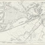
Kent VIII.8 (includes: Bexley; Chislehurst and Sidcup) - 25 Inch Map
1937
Ordnance Survey
1:3k
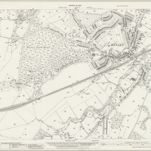
Kent VIII.8 (includes: Bexley; Chislehurst and Sidcup) - 25 Inch Map
1930
Ordnance Survey
1:3k
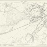
Kent VIII.8 (includes: Bexley; Chislehurst and Sidcup) - 25 Inch Map
1908
Ordnance Survey
1:3k
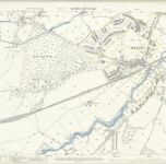
Kent VIII.8 (includes: Bexley; Chislehurst and Sidcup) - 25 Inch Map
1895
Ordnance Survey
1:3k
RAF Aerial Collection (1945 - 1949)
1947
RAF
1:5k
RAF Aerial Collection (1945 - 1949)
1947
RAF
1:5k
RAF Aerial Collection (1945 - 1949)
1947
RAF
1:5k
RAF Aerial Collection (1945 - 1949)
1947
RAF
1:5k
RAF Aerial Collection (1945 - 1949)
1947
RAF
1:5k
RAF Aerial Collection (1945 - 1949)
1947
RAF
1:5k
História
Mapas antigos de Bexley (Londres)
Descubra o passado de Bexley (Londres) nos mapas históricos
Mapas antigos de Bexley (Londres)
Descubra o passado de Bexley (Londres) nos mapas históricos
Explorar os mapas
Descobrir a história
Região-mãe
Inglaterra
Locais relacionados